Ever since the Orange Revolution of 2004, memory wars have shaken Ukraine almost without interruption. The battle has been fought by proponents of two historical narratives—one post-Soviet, strongly influenced by the Soviet-era Russocentric and procommunist interpretation of the past, the other ethnonational, with strong anticommunist and often anti-Russian overtones rooted in the nationalist resistance to Soviet rule during and after World War II. The Ukrainian liberal camp, represented by a significant group of Ukraine’s leading historians and backed by pragmatic elements in the Ukrainian government and political elite, found itself embroiled in this struggle between two radically different visions of the Ukrainian past. The liberal narrative of Ukrainian history, with its inclusive attitude toward citizens who were not ethnic Ukrainians, helped lead the country toward independence in the late 1980s and early 1990s but was unable to regain ground lost after the polarization of Ukrainian politics, including the politics of memory, in the course of the Orange Revolution.[1]
The polarization of Ukrainian politics after 2004 had a clear regional dimension, pitting the east of the country, nostalgic for the Soviet period, against the west, which was anticommunist and oriented toward Europe. Under the circumstances, the politics of memory became an important instrument for political parties trying to mobilize their regional electorates. But “lived memory,” rooted in the actual history of a given region, began to be modified by current politics in this period. The city of Kyiv, for example, which had never been part of any other country than the Russian Empire or the USSR since the mid-seventeenth century, accepted many elements not only of liberal national but also nationalist narratives of Ukrainian history, as did the population of other urban centers in predominantly rural central Ukraine. In regions east of the Dnieper, elements of national and nationalist narratives made inroads not only in rural regions such as Poltava but also in industrial centers like Dnipro (formerly Dnipropetrovsk).
Given the close connection between memory and politics in Ukraine, it is only natural to start our discussion of the present-day geography of memory by considering the country’s regional political preferences, as shown on Map 1. Political scientists and sociologists who study Ukraine have come up with various divisions of Ukrainian political space into macro-regions, usually based on voter behavior but also including historical and cultural components, especially linguistic preferences. The number of macro-regions typically varies from two to five. This discussion identifies four macro-regions, but the regional map that we have chosen differs somewhat from generally accepted political-science models..[2]
MAP 1
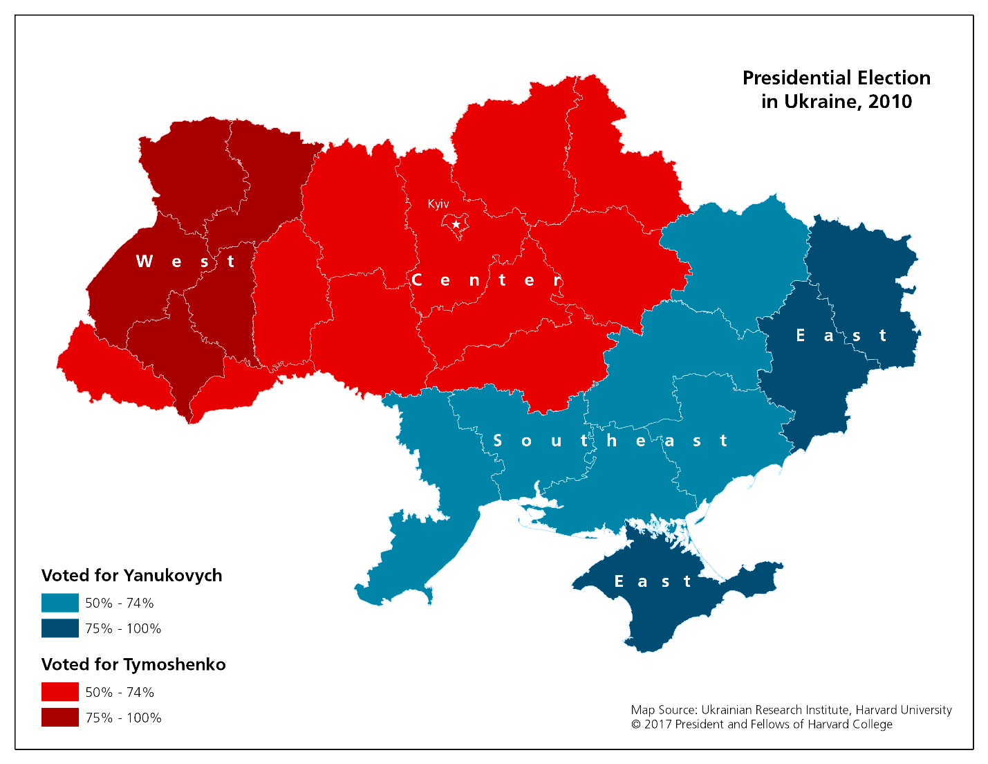
For the purposes of our analysis, we found most useful the regional division of Ukraine based on a map of the 2010 presidential elections. The map reproduced above divides Ukraine into two parts and then splits those zones into two additional segments, yielding a division of the country into four macro-regions. The basis for this division is the number of votes cast for the two major contenders in the 2010 presidential elections, Viktor Yanukovych and Yulia Tymoshenko. The areas where more than 75 percent voted for Tymoshenko constitute one macro-region, and those where she received between 50 and 74 percent of the vote are another. Two more macro-regions consist of those areas where more than 75 percent voted for Yanukovych and those where he gained 50 to 74 percent of the vote. The two regions in which Yanukovych and Tymoshenko achieved majorities constitute super-regions dividing Ukraine into eastern and western halves. To a large degree, the divisions indicated on the map came into existence in the 2004 presidential elections that produced the Orange Revolution.
For the purposes of this discussion the regions marked on the map can be labeled West, Center, Southeast, and East, the latter being a composite region that includes the Donetsk and Luhansk oblasts of eastern Ukraine and the Crimean peninsula. Since we find this map and its regional divisions by far the most useful geographic tool for analyzing the data produced by the surveys, we shall use the four regional names just mentioned in our further discussion.